


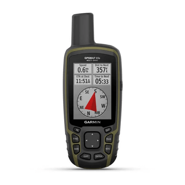
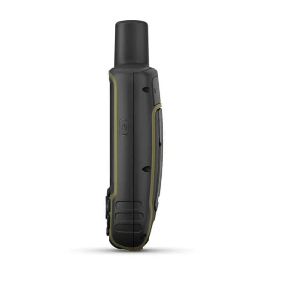
GPSMAP 65s
Multi-band/multi-GNSS handheld with sensors
FIND YOUR WAY IN THIS BIG, WIDE WORLD
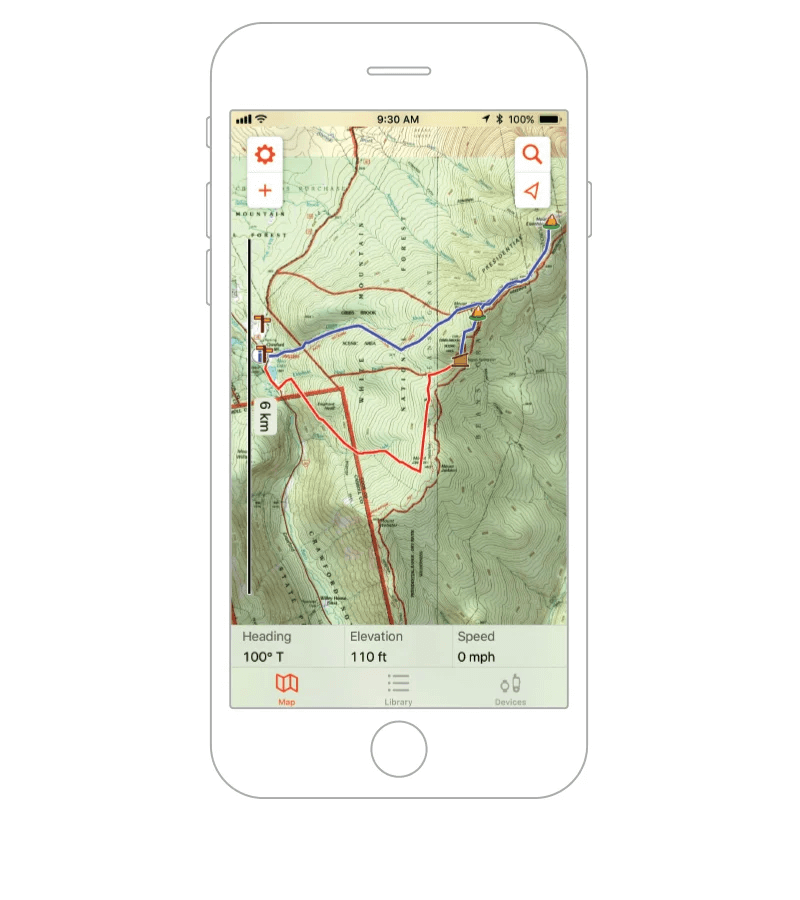
Explore more with this rugged handheld that offers optimal tracking accuracy, a 2.6-inch colour display and preloaded maps.
Don’t miss a detail with this large, sunlight-readable colour display. | Lead the way in challenging locations with multi-band technology and expanded GNSS satellite support. | Cross the countryside with routable TopoActive Europe maps. |
Plot your next move with built-in navigation sensors. | Organise your adventure from anywhere with the Garmin Explore™ website and app1. | Travel with up to 16 hours of battery life in GPS mode. |

Follow your
path.
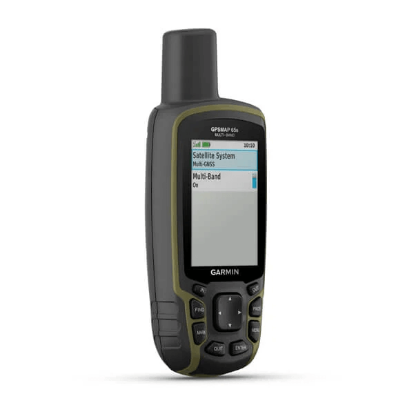
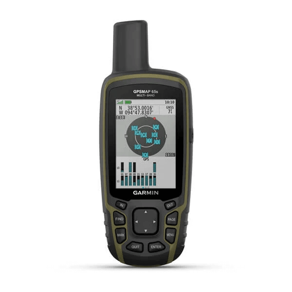
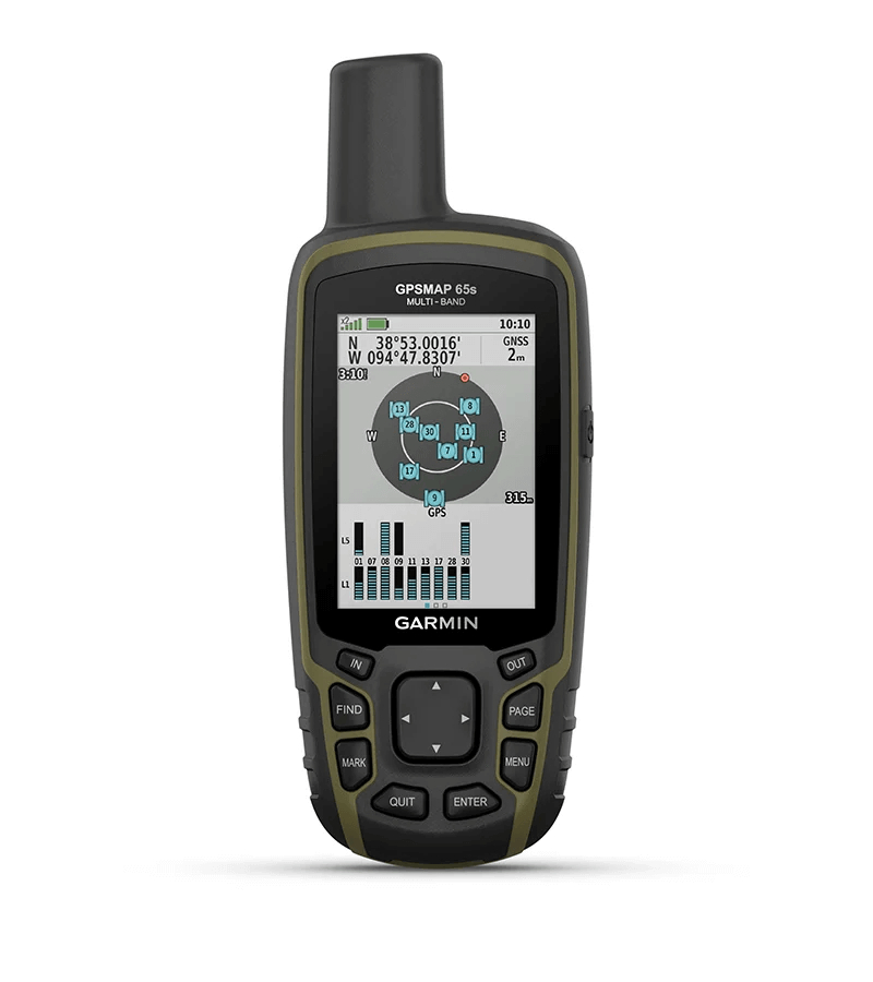
EXPANDED GNSS SUPPORTMulti-band technology and expanded GNSS support (GPS, GLONASS, Galileo, QZSS and IRNSS) provide optimal accuracy in steep country, urban canyons and forests with dense trees. |
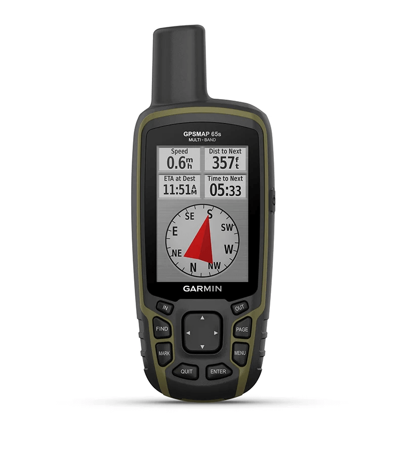
ABC SENSORSNavigate every trail with ABC sensors, including an altimeter for elevation data, barometer to monitor weather and 3-axis electronic compass. |
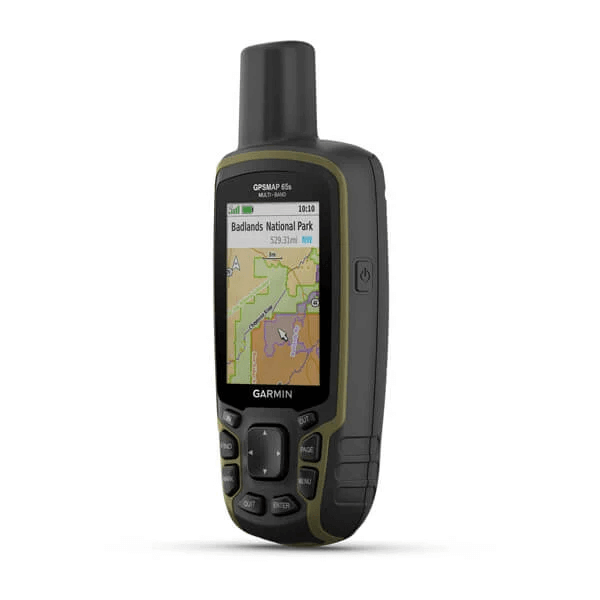
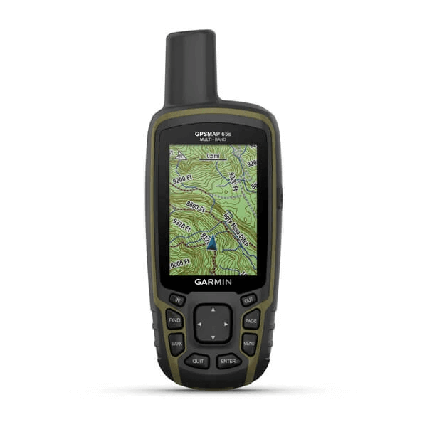
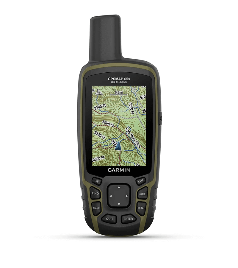
PRELOADED TOPOACTIVE EUROPE MAPSPreloaded TopoActive Europe maps provide detailed views of routable street and off-road networks, waterways, natural features, land use areas, buildings and more. |
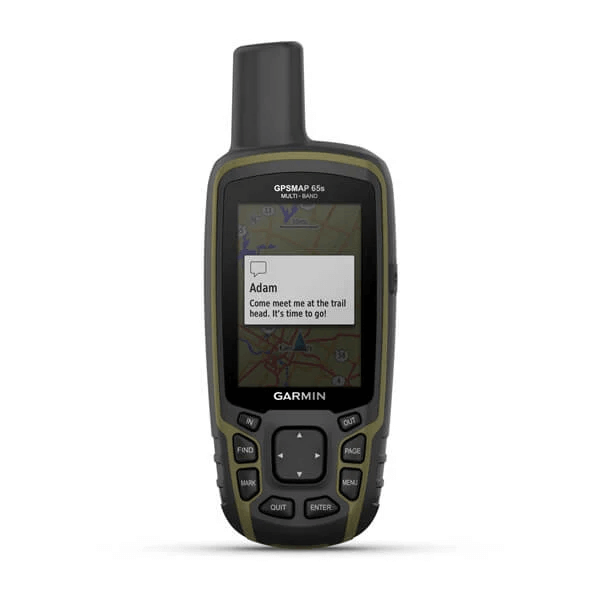
SMART NOTIFICATIONSReceive emails, texts and alerts right on your handheld when paired with your compatible device. |
GARMIN EXPLORE APPPlan, review and sync waypoints, routes and tracks by using the Garmin Explore app1 and website. You can even review completed activities while still in the field. | GEOCACHINGGet automatic cache updates from Geocaching Live, including descriptions, logs and hints. |

General
| PHYSICAL DIMENSIONS | 6.1 x 16.0 x 3.6 cm |
| DISPLAY SIZE | 3.6 x 5.5 cm; 2.6-inch diagonal (6.6 cm) |
| DISPLAY RESOLUTION | 160 x 240 pixels |
| DISPLAY TYPE | Transflective, 65K colour TFT |
| WEIGHT | 217 g with batteries |
| BATTERY TYPE | 2 AA batteries (not included); NiMH or Lithium recommended |
| BATTERY LIFE | 16 hours |
| WATER RATING | IPX7 |
| HIGH-SENSITIVITY RECEIVER | |
| INTERFACE | High-speed mini USB and NMEA 0183 compatible |
| MEMORY/HISTORY | 16 GB (user space varies based on included mapping) |
Maps & memory
| PRELOADED MAPS | Yes (TopoActive Europe; routable) |
| ABILITY TO ADD MAPS | |
| BASEMAP | |
| AUTOMATIC ROUTING (TURN BY TURN ROUTING ON ROADS) | |
| MAP SEGMENTS | 3,000 |
| BIRDSEYE | 250 BirdsEye Imagery files |
| INCLUDES DETAILED HYDROGRAPHIC FEATURES (COASTLINES, LAKE/RIVER SHORELINES, WETLANDS AND PERENNIAL AND SEASONAL STREAMS) | |
| INCLUDES SEARCHABLE POINTS OF INTERESTS (PARKS, CAMPGROUNDS, SCENIC LOOKOUTS AND PICNIC SITES) | |
| DISPLAYS NATIONAL, STATE AND LOCAL PARKS, FORESTS, AND WILDERNESS AREAS | |
| STORAGE AND POWER CAPACITY | Yes (32 GB max microSD™ card) |
| WAYPOINTS/FAVOURITES/LOCATIONS | 5,000 |
| TRACKS | 200 |
| TRACK LOG | 10,000 points, 200 saved tracks |
| ROUTES | 200, 250 points per route; 50 points auto routing |
Sensors
| GPS | |
| GLONASS | |
| GALILEO | |
| QZSS | |
| BAROMETRIC ALTIMETER | |
| COMPASS | Yes (tilt-compensated 3-axis) |
| GPS COMPASS (WHILE MOVING) | |
| MULTI-BAND FREQUENCY SUPPORT |
Daily Smart Features
| SMART NOTIFICATIONS ON HANDHELD | |
| VIRB® CAMERA REMOTE | |
| COMPATIBLE WITH GARMIN CONNECT™ MOBILE |
Outdoor recreation features
| POINT-TO-POINT NAVIGATION | |
| COMPATIBLE WITH BASECAMP™ | |
| AREA CALCULATION | |
| HUNT/FISH CALENDAR | |
| SUN AND MOON INFORMATION | |
| GEOCACHING-FRIENDLY | Yes (paperless) |
| CUSTOM MAPS COMPATIBLE | yes (500 custom map tiles) |
| PICTURE VIEWER |
Outdoor applications
| COMPATIBLE WITH GARMIN EXPLORE™ APP | |
| GARMIN EXPLORE WEBSITE COMPATIBLE |
Connections
| WIRELESS CONNECTIVITY | Yes - Bluetooth®, ANT+® |
- GPSMAP 65s
- USB cable
- Carabiner clip
- Documentation