
ՄԵԿ ՏԱՐԻ ՄԵԿ ԼԻՑՔԱՎՈՐՈՒՄՈՎ
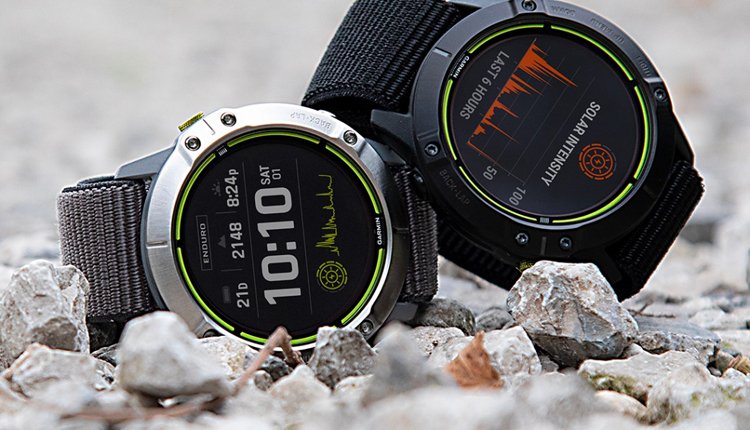
2019 թ․-ին «Գարմին» ընկերությունը առաջին անգամ օգտագործեց «Solar» տեխնոլոգիան (մարտկոցի արևային լիցքավորում) ժամացույցների մեջ, դրանով իսկ ավելի արդյունավետ դարձրեց սմարթ ժամացույցների կիրառումը ակտիվ կյանքում։ Առաջինը Fenix 6X մոդելն էր, որն արդեն իսկ տպավորիչ 21 օր մեկ լիցքավորումից աշխատելու հնարավորությունը դարձրեց 24 օր, ինչը մեծ արձագանք գտավ շուկայում։
2020 թ․-ին ընկերությունը թողարկեց մի քանի մոդելների թարմացված տարբերակները՝ կիրառելով «Solar» տեխնոլոգիան։ Այս կոնտեքստում Գարմինի Instinct solar մոդելը ստացավ հնարավորություն մեկ լիցքավորումով աշխատել գրեթե անվերջ:
Սա անշուշտ կգնահատեն արշավներով, որսորդությամբ, էքստրեմալ տուրիզմով զբաղվողները, ում համար հաճախակի լիցքավորումը անհասանելի է։
2021 թ-ին Գարմինը թողարկեց Enduro ժամացույցը, որն արտաքնապես նման է առաջատար Fenix 6X մոդելին, սակայն ունենալով պայծառ, գունավոր էկրան, մեկ լիցքավորումով կարող է աշխատել մինչև մեկ տարի։
«Գարմին» ընկերության ժամացույցները շուկայում առկա մնացած բոլոր բրենդների ժամացույցներից տարբերվում է իր լայն տեսականիով (ոճային, սպորտային, արշավային), գրավիչ տեսքով, բարձր որակով, ճշգրիտ չափումներով, ինչպես նաև իր բազմաֆունկցիոնալությամբ։
Հատկանշական է, որ շատ գնորդներ ընտրում են Garmin ժամացույցներն, իրենց ապրելակերպը բարելավելու համար։
Հետաքրքիր առանձնահատկություններից են՝
- քնի մոնիթորինգը, պուլսի, սթրեսի, ինչպես նաև արյան մեջ թթվածի հագեցվածության չափումը, մարմնի էներգիայի բախշման հաշվարկը, և նմանատիպ այլ ֆունկցիաներ՝ ուղղված կյանքի որակի բարելավմանը։
- Արշավի սիրահարների համար հասանելի են GPS նավիգացիոն համակարգ, բարձրաչափ, կողմնացույց, հետագծի կառուցում և այլն։
- Սպորտի սիրահարների համար մարզումների բազմաթիվ ծրագրեր՝ անձնական տվյալների հավաքագրմամբ և վերլուծությամբ, Նույնիսկ անձնական մարզիչ, որը կկազմի Ձեր մարզումների պլանը և չի բարկանա Ձեզ վրա։
Այս ամենի հետևում կանգնած են գիտնականներ, բժիշկներ, սպորտսմեններ և իհարկե ինֆորմացիոն տեխնոլոգիաներ, որի շնորհիվ էլ ապահովվում է բարձր որակ և ճշգրիտ աշխատանք։
Garmin on Mars
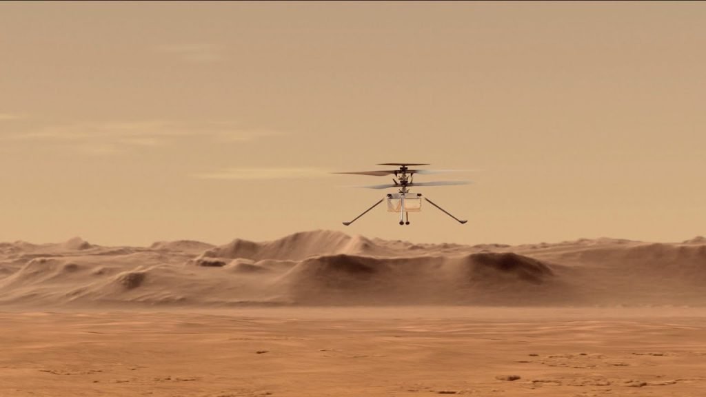
April 5, 2021
When NASA’s Ingenuity helicopter takes off in the first controlled flight on Mars, the Garmin LIDAR-Lite v3 optical distance measurement sensor will help measure how high the aircraft goes.
With the Ingenuity helicopter, NASA will attempt the first instance of controlled flight on another planet — and the history-making mission is taking place with Garmin on board. Ingenuity landed safely at Jezero Crater on Mars on Feb. 18, 2021, attached to the belly of the Mars 2020 Perseverance Rover. Next on the helicopter’s to-do list is to safely unfold from its position on the rover, deploy to the Martian surface, charge using solar power, confirm communications with flight operators on Earth, gear up the rotor blades and — finally — lift off and fly autonomously for the first time.
So how is Garmin involved? Our technology — LIDAR-Lite v3 — will be measuring the distance from the helicopter to the ground. Ingenuity’s flight altitude goal is to get up to 15 feet (or 5 meters) from the surface of Mars for a flight lasting up to 90 seconds. To put this to scale, remember that the atmosphere on Mars is less than 1% as dense as Earth’s — and that Wilbur and Orville Wright’s first flight on Earth only lasted for 12 seconds.
Ingenuity weighs 4 pounds on Earth, which translates to 1.5 pounds on Mars, and its rotors measure about 4 feet from tip to tip. This makes LIDAR-Lite v3 the perfect compact, high-performance optical distance measurement sensor solution. Below, Garmin design engineer Bob Lewis, who helped develop this technology, explains the advantages of choosing LIDAR-Lite on a mission as important as this.
What is a LIDAR-Lite device, and how does it work?
The LIDAR-Lite module would be referred to as an altimeter. It basically is measuring the distance between the helicopter and the ground, and it uses infrared pulses of light that are projected down to the ground. Then the light returns, and it measures the time it takes for the light to propagate from the helicopter down to the ground and back up again. It was probably chosen because it’s very, very light, and the helicopter — because it’s operating in a low density of atmosphere — can’t carry a lot.
How is LIDAR-Lite typically used on Earth?
It’s used for measuring distance in a variety of applications — typically distances of up to about 40 meters. And it’s pretty accurate. It’s accurate down to a little bit under an inch, so it’s useful in a variety of areas. It’s been used a lot in drones as an altimeter to measure the drone’s height off the ground. It’s been used in some robotics applications for scanning a room. One of the characteristics of this optical system is that it has a very well-focused beam, so the beam doesn’t spread very much, and you can scan 360 degrees over the horizon and get a map for the room. But anywhere you’re trying to measure a distance accurately and with a fast update rate, it could be used for systems that are needing this information for navigation.
If you get too slow an update rate, you can’t really move quickly. It can provide updates at hundreds of cycles per second.
Does Garmin have other products that use LIDAR-Lite technology?
It’s actually being used in a variety of other Garmin products. In NASA’s case, I suspect it’s primarily used just for measuring distance off the ground, but if you combine the distance to the ground with the camera system, you can actually use that for navigation. We have a handheld golf range finder, the Approach® Z82, that has that technology. There are also sportsman products, the Xero® A1i Bow Sight and the Xero X1i® Crossbow Scope, that measure the distance to a target, and based on how far away you are, it will calculate how much airdrop there’s going to be. So if you’re 50 yards away, that arrow is going to drop quite a bit — and LIDAR-Lite basically gives you a new pointing location that compensates for that difference. It can be used in all kinds of unique applications.
Interested in following along on this historic adventure? You can track NASA’s Ingenuity milestones here.