
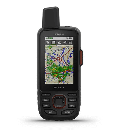
GPSMAP 66i


AMD399000
GPS handheld and satellite communicator
Description
TopoActive Mapping
BirdsEye Select 1:25k Bundle
inReach® Technology
Multi-Band Technology
MORE ADVENTURE. LESS WORRY.
Precise navigation meets global communication in the rugged GPSMAP 66i button-operated GPS handheld and satellite communicator1 featuring Garmin TopoActive Europe mapping and inReach® technology.
See it in any light. Use it in any conditions. GPSMAP 66i was built for that. | When mobiles can’t connect, inReach can. Communicate with confidence. | Multi-GNSS satellite support puts superior navigation at your fingertips. |
Get maps as pretty as a picture and just as detailed — without a subscription. | Know the terrain before you’re in it, with preloaded TopoActive maps of Europe. | Stay out there longer with up to 35 hours of battery life in tracking mode and up to 200 hours in Expedition mode. |

Know the way.
MULTI-GNSS SUPPORT
Access multiple global navigation satellite systems (GPS and Galileo) to track in more challenging environments than GPS alone.
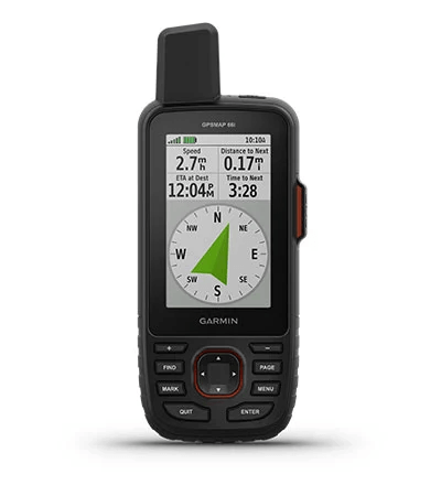
ABC SENSORS
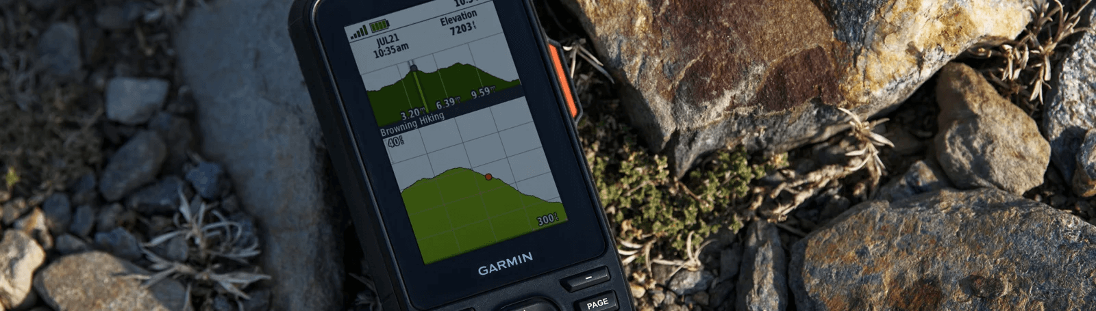
Navigate every trail with ABC sensors, including an altimeter for elevation data, barometer to monitor weather and 3-axis electronic compass.
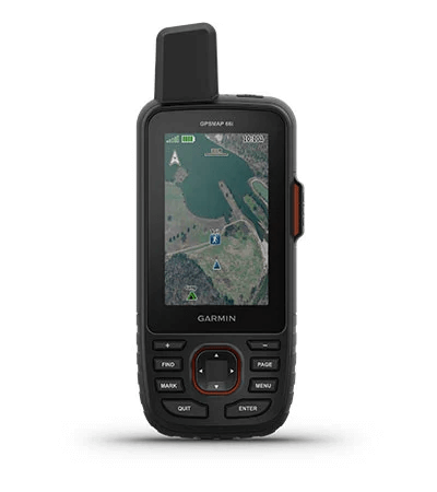
BIRDSEYE SATELLITE IMAGERY
Download high-resolution, photo-realistic maps directly to your device without an annual subscription. Easily find trails, pick stand locations, find parking, create waypoints and more.

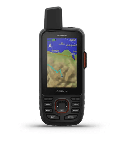
PRELOADED TOPOACTIVE EUROPE MAPS
Preloaded TopoActive Europe maps show you summits, parks, coastlines, rivers, lakes and geographical points.

Stay in touch by
using inReach
technology.
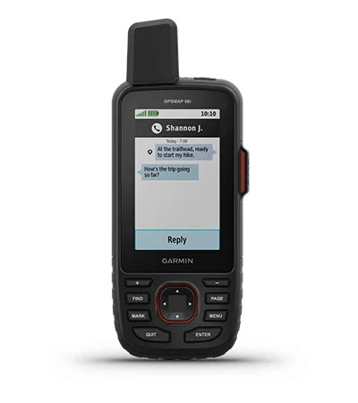
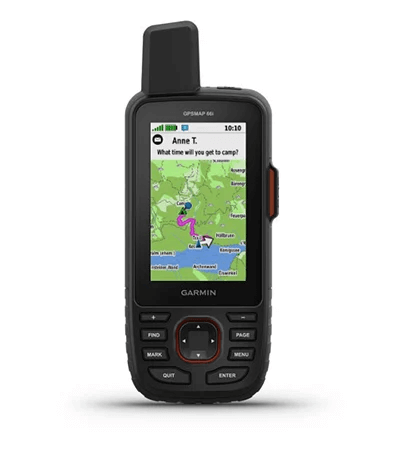
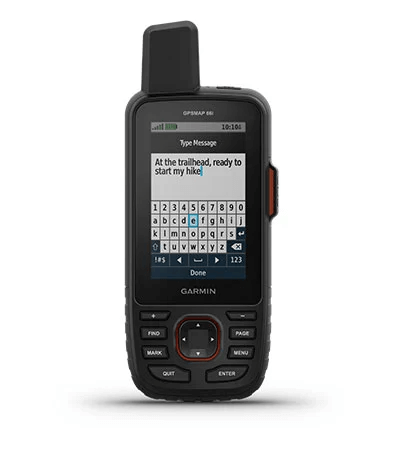
TWO-WAY MESSAGING
Exchange text messages with loved ones or friends, post to social media, or communicate from inReach to inReach in the field. Satellite subscription required.
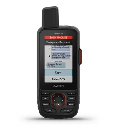
INTERACTIVE SOS ALERTS
In case of emergency, trigger an interactive SOS message to GEOS, a professional 24/7 global monitoring and response centre. Satellite subscription required.
LOCATION SHARING
Track your location, and share it with those at home or out in the field. They’ll be able to see your progress or ping your device for your GPS location and more. Satellite subscription required.
100% GLOBAL IRIDIUM® SATELLITE NETWORK
Instead of relying on mobile coverage, now your messages, SOS alerts and tracking are transferred via the global Iridium satellite network. Satellite subscription required.
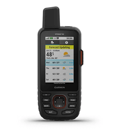
OPTIONAL INREACH WEATHER
Use inReach connectivity to get detailed weather updates on GPSMAP 66i or a compatible device paired with the Garmin Explore™ app. Request weather forecasts for your current location, waypoints or destinations on your route.
ACTIVE WEATHER
When paired with your compatible smartphone you can get real-time forecast information and live weather radar, so you’re always aware of the surrounding conditions.
Be adventure
ready.
BUILT FOR ADVENTURE
This handheld is built to military standards for thermal, shock and water performance (MIL-STD-810), and it’s even compatible with night vision goggles.
LED FLASHLIGHT
The GPSMAP 66 series helps you keep gear to a minimum with a built-in LED flashlight that can be used as a beacon to signal for help.
GARMIN EXPLORE APP
Plan, review and sync waypoints, routes and tracks by using the Garmin Explore mobile app and website. You can even review completed activities while still in the field.
BATTERY LIFE
Turn on Expedition mode, and get up to 200 hours of battery life while using inReach technology. In the default tracking mode, you get up to 35 hours of battery life, and your device will save your location every 10 minutes.
Գլխավոր
| Սարքի չափսը | 6.6 x 16.3 x 3.5 սմ |
| Էկրանի չափսը | 3.8 x 6.3 սմ; 3″ անկյունագիծ(7.6 սմ) |
| Էկրանի խտությունը | 240 x 400 pixels |
| Էկրանի տեսակը | տրանսֆլեկտիվ, գունավոր TFT |
| Քաշը | 241 գ |
| Մարտկոցի տեսակը | Վերալիցքավորվող լիթիում-իոնային |
| Մարտկոցի աշխատանքը | Up to 35 hours at 10-minute tracking; up to 200 hours at 30-minute tracking (power save mode) |
| Ջրակայունություն | IPX7 |
| MIL-STD-810 | այո (thermal, shock, water) |
| Բարձր զգայունության ընդունիչ | |
| Միացման տեսակը | high speed micro USB and NMEA 0183 compatible |
| Հիշողությունը | 16ԳԲ |
Քարտեզներ և հիշողություն
| Ներառված քարտեզներ | այո (տեղագրական) |
| Քարտեզներ ավելացնելու հնարավորություն | |
| Բազային քարտեզ | |
| Ավտոմատ երթուղի կազմում | |
| Քարտեզի հատվածներ | 15000 |
| BIRDSEYE | այո (անմիջապես սարքին) |
| Ջրագրություն | |
| Հետաքրքրի կետերի որոնում | |
| Ազգային, պետական և տեղական զբոսայգիների, անտառների ու անապատային տարածքների ցուցադրում | |
| Հիշողության քարտի բնիկ | microSD™ card (չի ներառում) |
| Սեփական կետերի հիշողություն | 10,000 |
| Երթուղիների քանակ | 250 |
| Երթուղիների պահոց | 20,000 points, 250 saved gpx tracks, 300 saved fit archives |
| ROUTES | 250 |
| RINEX LOGGING |
Սենսորներ
| GPS | |
| GALILEO | |
| Բարոմետրիկ բարձրաչափ | |
| Կողմնացույց | |
| GPS Կողմնացույց (միայն շարժման ժամանակ) |
Առօրյա սմարթ հատկություններ
| CONNECT IQ™ (ներբեռնվող ժամացույցի էկրաններ, ծանուցումներ, ծրագրեր) | |
| Խելացի հնարավորություններ | |
| Եղանակ | |
| VIRB® տեսախցիկի հեռահար կառավարում | |
| Համատեղելի է GARMIN CONNECT™ մոբայլի հետ | |
| Ակտիվ եղանակ |
Անվտանգության հնարավորություններ
| LIVETRACK |
Դրսի մարզման առանձնահատկություններ
| Կետից կետ ուղղորդում | |
| Համատեղելի է BASECAMP™ հետ | |
| Մակերեսի հաշվարկ | |
| Ձկնորսի/որսորդի օրացույց | |
| Արևի/լուսնի օրացույց | |
| XERO™ | |
| GEOCACHING-FRIENDLY | այո (Geocache Live) |
| Անհատական քարտեզների համատեղելիություն | այո (500 հատ) |
| Նկարների դիտում | |
| LED BEACON FLASHLIGHT |
inReach® առանձնահատկություններ
| INTERACTIVE SOS | |
| SEND AND RECEIVE TEXT MESSAGES TO SMS AND EMAIL | |
| SEND AND RECEIVE TEXT MESSAGES TO OTHER INREACH DEVICE | |
| EXCHANGE LOCATIONS WITH OTHER INREACH DEVICE | |
| MAPSHARE COMPATIBLE WITH TRACKING | |
| VIRTUAL KEYBOARD FOR CUSTOM MESSAGING | |
| INREACH REMOTE COMPATIBLE |
Բացօթյա ծրագրեր
| Համատեղելիություն GARMIN EXPLORE™ ծրագրի հետ | |
| Համատեղելիություն GARMIN EXPLORE կայքի հետ |
Կապեր
| Անլար համակցում | այո (Wi-Fi®, BLUETOOTH®, ANT+®) |
Հավելյալ
| Հավելյալ |
|
Device only
- Edge 830
- Flush out-front mount
- Standard mount
- Tether
- USB լար
- Փաստաթղթեր
Sensor bundle
- Edge 830
- Flush out-front mount
- Standard mount
- Speed sensor
- Cadence sensor
- Heart rate monitor
- Tether
- USB լար
- Փաստաթղթեր
Additional information
| Shop by Series | GPSMAP |
|---|